


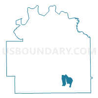
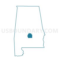
New Hope Church, Lowndes County, Alabama
About
Outline

Summary
| Unique Area Identifier | 522313 |
| Name | New Hope Church |
| County | Lowndes County |
| State | Alabama |
| Area (square miles) | 9.10 |
| Land Area (square miles) | 9.07 |
| Water Area (square miles) | 0.03 |
| % of Land Area | 99.62 |
| % of Water Area | 0.38 |
| Latitude of the Internal Point | 32.03309130 |
| Longtitude of the Internal Point | -86.54034440 |
Maps

Graphs
Select a template below for downloading or customizing gragh for New Hope Church, Lowndes County, Alabama


Neighbors
Neighoring Voting District (by Name) Neighboring Voting District on the Map
- Community Center, Lowndes County, AL
- Fort Deposit National Guard Armory Voting District, Lowndes County, AL
- Fort Deposit National Guard Armory Voting District, Lowndes County, AL
- New Hope Church, Lowndes County, AL
- New Hope Church Voting District, Lowndes County, AL
- New Hope Church Voting District, Lowndes County, AL